





Thursday, Jun 12, 2025 22:15 [IST]
Last Update: Wednesday, Jun 11, 2025 16:42 [IST]


Central panel flags increased flood risk as Teesta found shifting rightward towards settlement zones
GANGTOK, : The Teesta riverbed at Melli stretch has risen by nearly 14 metres due to heavy sediment deposition following the GLOF-triggered flash flood in October 2023, drastically reducing the river’s carrying capacity and triggering serious flood risk concerns.
The implications are serious, including increased flood hazard, potential bank overtopping, and altered flow paths, warned the committee appointed by Jal Shakti Ministry in its report of April 2025.
The committee had been tasked by the Jal Shakti Ministry to study the morphological impacts caused by the GLOF on Teesta River and to propose remedial measures. The panel, in its report, highlights Melli as the most severely affected stretch in the 140-km Teesta study corridor between Zema (Sikkim) and Teesta Bazar (West Bengal). While deposition was reported at several locations, the accumulation at Melli stands out both in magnitude and implications.
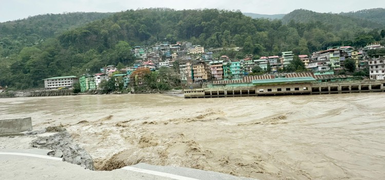
During the 2024 monsoon, the Teesta River water levels had increased considerably, flooding the stadium located at Melli Bazaar on the right bank while also coming dangerously close to NH 10 on the left bank.
As per the Central committee, the Melli site is characterized by extreme aggradation, with cross-section data indicating a bed level rise of nearly 14 meters - the highest recorded in the entire study reach.
“Although the lateral expansion is minimal, the substantial sediment deposition has drastically reduced the channel's capacity. The implications are serious, including increased flood hazard, potential bank overtopping, and altered flow paths,” said the Teesta Morphology Committee in its report.
Observed cross section data before and after GLOF event indicates there is a huge deposition in the river bed….the river is shifting rightward toward settlement zones, posing significant safety concerns, said the committee.
River morphology is concerned with the shapes of river channels and how they change over time. The morphology of a river channel is a function of a number of processes and environmental conditions on multiple spatial and temporal scales. Watershed features that control river morphology include topography, discharge, sediment supply and vegetation.
The massive sediment load on lower belts of Teesta River is attributed to the 2023 flash flood. As the Teesta’s gradient flattens downstream from Mangan, its capacity to transport sediment decreases, causing heavier deposits at locations like Singtam, Rangpo, Melli and Teesta Bazar.
The committee has mentioned that erosion and deposition are natural process in a river system and over a period of time river profile gets stabilized and river regains its regime on its own eventually. “The same view is also applicable to Teesta in the present case, where owing to the GLOF event, the river has witnessed erosion and deposition depending upon its stretch albeit in a very short period of time. To improve the channel conveyance, dredging throughout the river reach is not considered techno-economically viable,” the committee observed.
The committee suggested that certain duration should be allowed to the river to stabilize its regime. At this stage no extensive dredging/ earthwork removal need to be done, unless there is any specific requirement and this should be based upon scientific study, it said.
It was also recommended that river training/bank protection works at locations threatening habitation may be taken up after detailed geological, morphological and hydrological survey and investigation.
The Jak Shakti Ministry’s Teesta Morphology Committee had undertaken a site visit from July 15, 2024 to July 19, 2024 covering the affected areas in Sikkim and West Bengal along Teesta River.
The committee’s findings are based on a combination of satellite imagery analysis and on-ground field visits. Sentinel-2A multispectral images from before and after the GLOF event were used to assess morphological changes, while field data, including cross-sectional surveys, provided critical ground knowledge at key locations like Melli.
Pic caption: The Teesta River flows in high intensity along Melli Bazaar during the recent pre-monsoon rains. The area has seen a dramatic rise in riverbed levels post-GLOF, raising fresh flood concerns.